Anreiseinformationen
Routenplanung mit dem Auto
![]() Die folgenden Links nutzen Google maps. Die Seiten werden in neuem Tab/Fenster geöffnet.
Die folgenden Links nutzen Google maps. Die Seiten werden in neuem Tab/Fenster geöffnet.
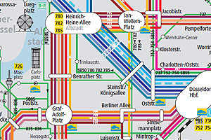
Routenplanung mit öffentlichen Verkehrsmitteln
 Der online-Dienst der Deutschen Bahn AG bietet auch den öffentlichen Nahverkehr an. Die Seiten werden in neuem Tab/Fenster geöffnet. TIP: Der Link "Detailansicht" für weitere Informationen zu den einzelnen Verbindungen


")
")